 |
| Hurricane Fran making landfall in 1996 (Source: NOAA) |
Tropical
storms and hurricanes can have far-reaching effects to areas far removed from
the storm’s center. The DC Metro Area
has felt the impacts of several significant tropical systems. As the start of hurricane season approaches
on June 1, it’s a good time to review some of these past storms.
The
National Hurricane Center tracked major Hurricane Irene in August 2011. Fortunately, Irene weakened to a Category 2 before
it made landfall along the Mid-Atlantic Coast.
Irene’s impacts were felt from North Carolina to New England. On August 27-28, Irene produced a 60 mph wind
gust and 3.83” of rain at National Airport, 4.69” at BWI Airport and Dulles
Airport had a storm total of 1.41”.
Ivan
reached Category 5 intensity three times while over the ocean in September 2004
and remains one of the Atlantic’s most powerful hurricanes on record. Once Ivan made landfall along the U.S. Gulf
Coast, it caused a significant amount of damage well inland. Hurricanes and tropical storms are known to
spawn tornadoes when they make landfall.
The remnants of Ivan caused a tornado outbreak in the Mid-Atlantic
Region on September 17, 2004.
Hurricane Isabel was the Atlantic’s first Category 5 hurricane in nearly five years when it developed in 2003. Despite weakening considerably to Category 2 intensity before making landfall in North Carolina, Isabel still produced the highest storm surge on the Chesapeake Bay since 1933. A wind gust of 73 mph was reported in Richmond, Virginia and a 58 mph wind gust occurred at National Airport. Isabel’s winds were so significant that a total of 1.4 million power outages occurred just in the DC Metro Region (including 539,000 Pepco outages).
Hurricane Isabel was the Atlantic’s first Category 5 hurricane in nearly five years when it developed in 2003. Despite weakening considerably to Category 2 intensity before making landfall in North Carolina, Isabel still produced the highest storm surge on the Chesapeake Bay since 1933. A wind gust of 73 mph was reported in Richmond, Virginia and a 58 mph wind gust occurred at National Airport. Isabel’s winds were so significant that a total of 1.4 million power outages occurred just in the DC Metro Region (including 539,000 Pepco outages).
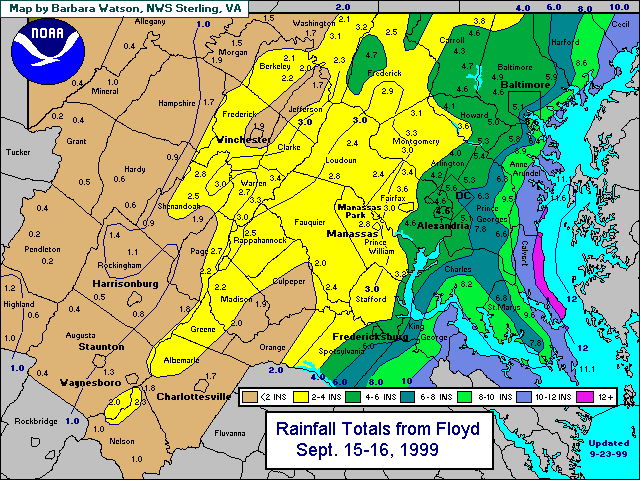
Hurricane Floyd was the most significant hurricane of the 1999 season. Like Irene and Isabel, Floyd made landfall in
North Carolina as a Category 2 hurricane.
Floyd brought flooding rainfall to a large portion of the Mid-Atlantic and
New England states. National Airport saw
a total of 3.67” and Dulles Airport got 2.56” of rain. Floyd occurred just three years after
Hurricane Fran impacted many of the same areas with flooding, wind damage and
isolated tornadoes.
Two other hurricanes also have significant places in Washington, D.C. history. The remnants of Hurricane Agnes caused devastating flooding across the eastern United States in June 1972. Washington, D.C. saw a total of 8.16” of rain from Agnes. That led June 1972 to be the wettest on record at the time and it now ranks as the third wettest June. Washington, D.C.’s highest wind gust on record remains the 98 mph gust that occurred on October 15, 1954 during Hurricane Hazel.
Two other hurricanes also have significant places in Washington, D.C. history. The remnants of Hurricane Agnes caused devastating flooding across the eastern United States in June 1972. Washington, D.C. saw a total of 8.16” of rain from Agnes. That led June 1972 to be the wettest on record at the time and it now ranks as the third wettest June. Washington, D.C.’s highest wind gust on record remains the 98 mph gust that occurred on October 15, 1954 during Hurricane Hazel.
Whether flooding
rainfall, damaging winds or severe weather, tropical storms and hurricanes are
dangerous systems that require attention and advance planning. NOAA will issue its forecast for the upcoming
hurricane seasons in the next few weeks.
No comments:
Post a Comment