 |
| Flash Flood Watches are In Effect Today (Source: NOAA) |
September
is the busiest month of the Atlantic hurricane season. Over the last 20 years, the DC Metro Region
has endured significant impacts from hurricanes.
2012: In late October, Sandy became the
most intense hurricane of the season as a Category 3 storm with sustained winds
of 115 mph and an unusually low air pressure of 940 millibars (mb), compared to
the average sea level air pressure of 1013.25 millibars. By comparison, while at peak intensity over
the open Atlantic Ocean, Hurricane Florence was a Category 4 hurricane with
sustained winds of 140 mph and a minimum air pressure of 939 mb.
Fortunately, Sandy weakened and was classified as a non-tropical system shortly before coming ashore in New Jersey. However, “Sandy” still brought record-setting rainfall to the Nation’s Capital with tropical storm force wind gusts. National Airport saw its second wettest October day on record with 3.85” on October 29, 2012, coupled with a peak wind gust of 61 mph. Another 0.84” of rain fell in the Nation’s Capital on October 30, 2012.
Fortunately, Sandy weakened and was classified as a non-tropical system shortly before coming ashore in New Jersey. However, “Sandy” still brought record-setting rainfall to the Nation’s Capital with tropical storm force wind gusts. National Airport saw its second wettest October day on record with 3.85” on October 29, 2012, coupled with a peak wind gust of 61 mph. Another 0.84” of rain fell in the Nation’s Capital on October 30, 2012.
2011: Hurricane Irene made landfall in
North Carolina as a Category 1 on August 27.
National Airport saw a storm total of 3.83” of rain and a peak wind gust
of 60 mph. However, areas south and east
of DC saw a lot more rain such as Waldorf, MD (6.70”) and Prince Frederick, MD
(8.33”). Irene’s rainfall in the
Nation’s Capital was especially significant since it accounted for nearly half
of the 8.92” of rain that month. It was
the wettest August in Washington, D.C. since 1967 (9.17”).
2003: At peak intensity over the open
Atlantic, Isabel was a rare Category 5 hurricane with sustained winds of 165
mph and a minimum central air pressure of 915 millibars. It weakened considerably to Category 2 status
before making landfall in North Carolina on September 18. The center of Isabel tracked west of the DC
Metro Region and caused significant tidal flooding along the Chesapeake Bay and
Tidal Potomac River.
Although
the highest wind gust from Isabel at National Airport was 58 mph, a 71 mph wind
gust was observed at the National Academy of Sciences downtown. A daily rainfall record of 2.28” also
occurred at National Airport on September 18.
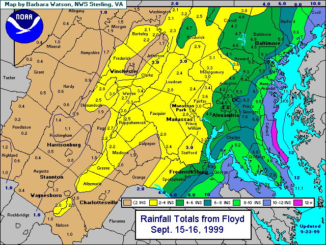
1999: Hurricane Floyd made landfall in
North Carolina as a Category 2 hurricane on September 16. Although gusty winds occurred in the DC Metro
Area, Floyd’s primary legacy was significant flooding. That’s because grounds were already saturated
following several days of heavy, thunderstorm-related rainfall in late-August
1999, combined with the remnants of Hurricane Dennis earlier that September. According to the National Weather Service, a
total of 3.67” of rain occurred at National Airport on September 16 along with
a peak wind gust of 55 mph.
Daily Rainfall Records (Source:
National Weather Service)
September
17:
Washington, D.C. – Reagan National Airport (DCA): 3.26” (1876)
Dulles International Airport, (IAD), Sterling, Virginia: 1.71” (2004)
Baltimore, MD (BWI Marshall Airport): 3.94” (1876)
Washington, D.C. – Reagan National Airport (DCA): 3.26” (1876)
Dulles International Airport, (IAD), Sterling, Virginia: 1.71” (2004)
Baltimore, MD (BWI Marshall Airport): 3.94” (1876)
September 18:
DCA: 2.28” (2003)
IAD: 1.76” (2003)
BWI: 2.13” (2003)
No comments:
Post a Comment