 |
| Hurricane Floyd, September 1999 (Source: NOAA) |
September is the most active month of the Atlantic hurricane season. That’s especially so in 2018 when, after a quiet six-week period from mid-July to late August, multiple tropical systems are currently active in the Atlantic Ocean including Florence, Helene and Isaac.
Hurricane Florence is the one that residents along the East Coast should be watching most closely. My colleagues and I on the WUSA9 Weather Team will be monitoring it carefully during the next few days.
Longtime DC Area residents may recall some of the most significant tropical systems that have impacted the Mid-Atlantic Region in previous years.
2003: Hurricane Isabel made landfall in North Carolina as a Category 2 hurricane on September 18. Isabel tracked west of Washington, D.C. as it weakened and brought the DC Metro Area a significant amount of heavy rain and gusty winds. Over one million power outages were observed around the Nation’s Capital, with significant coastal flooding in Old Town Alexandria in Virginia and in Annapolis, Maryland.
The highest tide in Annapolis reached 7.58 feet above normal, breaking the 1933 hurricane record. Flooding in Georgetown occurred with flood stage reaching 11.3 feet above normal and that also broke the 1933 hurricane surge record.
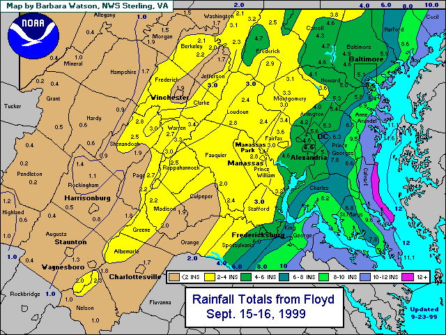
1999: Floyd made landfall in North Carolina as a Category 2 hurricane on September 16. It weakened as it tracked north to the DC Metro Area where it brought a prolific amount of rainfall. National Airport got 3.67” of rain while Dulles Airport got 2.89”. However, 4” to 7” rainfall totals were common in the DC Metro Area. Washington, D.C. averages only 3.72” of rain during the entire month of September.
1972: Although Agnes was a minimal Category 1 hurricane at peak intensity, it was a tropical storm when it impacted the Mid-Atlantic Region. After making landfall, Agnes quickly weakened and its remnants brought prolific amounts of rainfall and flooding to the Mid-Atlantic Region.
In the DC Metro Region, Agnes brought a total of nearly 8.2” of rain to National Airport (with 6.11” falling on June 21) while Dulles Airport in nearby Sterling, Virginia, saw a storm total of 13.65” (including a daily record of 10.67” of rain on June 21). This copious rainfall flooded an untold number roads and washed away some area bridges.
The Potomac River at Little Falls crested more than 12 feet above flood stage, according to the U.S. Geological Survey. As bad as the flooding was in the Nation’s Capital, it was even worse in Pennsylvania where it caused a dike to breach in Wilkes-Barre that almost destroyed the entire town.
1954: Hurricane Hazel made landfall in North Carolina on October 15 and traveled quickly northward. It was a Category 4 hurricane upon landfall with sustained winds of 135 mph -- the only Cat 4 on the Saffir-Simpson Scale to make landfall in North Carolina. Due to its relatively fast rate of speed northward, damaging winds occurred well inland.
Washington, D.C. experienced its highest wind gust on record during Hazel of 98 mph at National Airport. Significant storm surge occurred along the East Coast and in the Chesapeake Bay.
1933: A hurricane known as the “Chesapeake Bay Hurricane” made landfall near Virginia Beach and traveled up the Chesapeake Bay and just west of Washington, D.C. This caused very high storm surge on the west side of the Bay and in Washington, D.C. where the largest surge on record was observed (11 feet). It also created the inlet at Ocean City, Maryland. A total of 18 storm-related fatalities occurred, according to the National Weather Service.
No comments:
Post a Comment