Wednesday, September 9, 2020

DC’s September Weather Extremes


Denver, Colorado just went from temperatures in the 90s to seeing accumulating snowfall in less than 48 hours.  While nothing that dramatic has happened in the DC Metro Area, there have been some notable September weather extremes. 

During September DC averages 3.72” of rain, the fourth highest monthly average of the year.  That amount can fluctuate considerably depending on whether or not a tropical system impacts the DC Metro Area.  For example, Washingtonians saw 10.27” of rain in September 1999, largely the result of remnant moisture from Hurricane Dennis and record rainfall from Hurricane Floyd.  Also, the remnants of Tropical Storm Lee helped make September 2011 DC’s wettest October (8.84”) since 1999. 

DC’s fifth wettest September occurred just two years ago with 9.73”.  Part of that was the result of the remnants of Hurricane Florence, which brought heavy rain and severe weather to the DC Metro Area on September 17.  Last September was the opposite extreme in the nation’s capital because it finished as DC’s fourth driest.

DC’s warmest daily average high temperature during September is 84° on September 1, but falls to 74° by month’s end.  Despite the downward trend in daily average temperatures, DC still averages between three and four days of 90° heat in September dating back to the early 1990s.  In that time there have been as many as 10 days in the 90s twice in 1998 and 2010.  Each of those Septembers rank among DC’s 10 warmest. 

Some may wonder if having a wetter than average September could prevent it from ranking among DC’s warmest.  The short answer is no as was seen in September 2018.  That month not only ranked as DC’s fifth wettest with 9.73” of rain, but finished tied for DC’s sixth warmest.  Having nearly 60% of the month’s total rainfall on just three days helped allow for much of September 2018 to be warmer than average.  In fact, a total of only five days in all of September 2018 were cooler than average in the nation’s capital.

DC’s signature weather event so far this month was the severe weather event on September 3.  There were multiple reports of thunderstorm wind damage with an EF-1 tornado in the town of Edgewater, Maryland, near Annapolis.  Fortunately, the few days since then have been quiet on the weather front in the DC Metro Area.  However, September is also the busiest month of the Atlantic hurricane season so it’s important to keep an eye on all things weather as the month progresses.

Sunday, September 6, 2020

Perfect Labor Day Weekend Weather


Thursday, September 3 was an exceptionally active weather day in the Nation’s Capital.  My colleagues and I on the WUSA9 Weather Team issued a rare Red Weather Alert to coincide with the Tornado Watch that was issued by NOAA’s Storm Prediction Center.  There was a slew of severe weather in the DC Metro Area with multiple reports of wind damage and localized flooding.  The National Weather Service confirmed an EF-1 tornado touched down in Edgewater, Maryland near Annapolis with peak wind speeds of 90 mph.  Some minor damage was associated with it but, fortunately, no injuries or fatalities were reported. 

Following Thursday’s active weather and the two hot days with highs in the 90s so far this month, Washingtonians will have stellar weather for the Labor Day weekend.  Highs in the low to mid 80s with comfortable relative humidity have combined to produce ideal weather for outdoor activities.  No 90° heat is expected during the upcoming week in the Nation’s Capital, either.

September is the busiest month of the Atlantic hurricane season and several significant tropical systems have impacted the Mid-Atlantic Region during the last 20 to 30 years.  Some retired storm names include Floyd (1999) and Isabel (2003).  Every once in a while a decaying tropical system can produce tornadoes and severe weather, as well.  Such was the case with the remnants of Hurricane Ivan in 2004.

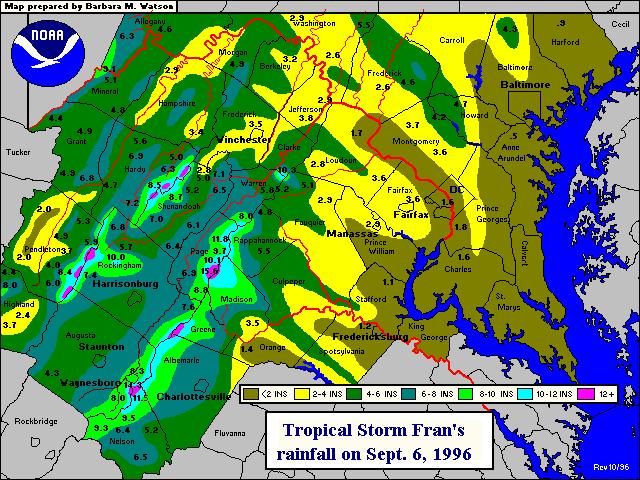
Hurricane Fran made landfall in North Carolina 24 years ago, yesterday.  It was a Category 3 hurricane when it made landfall with sustained winds of 115 mph.  Although other significant hurricanes have impacted North Carolina since then like Floyd (1999) and Florence (2018), Fran remains the last major hurricane to have made landfall in North Carolina.  It quickly tracked northward and had major impacts in the DC Metro Area, including record rainfall and damaging wind gusts on September 6, 1996.

Washington, DC averages between three and four days of 90° heat during the month of September, dating back to the early 1990s.  However, Washingtonians endured nine days of 90° heat just last September.  No triple-digit September heat has occurred in the Nation’s Capital since 1980.  It’s interesting to note that five of DC’s 10 warmest September’s have occurred since 2005, while the most recent of DC’s 10 coolest September’s was back in 1928.

Wednesday, September 2, 2020

The Arrival of Fall


August 2020 finished as DC’s thirteenth wettest with 8.73” of rain that also made it the wettest August since 2011.  Last month also finished 1.5° warmer than average in the Nation’s Capital.  For those of you tired of the heat and humidity of summer, September ushers in the start of meteorological fall (that runs from September 1 – November 30).  Meanwhile, astronomical fall gets underway on the autumnal or fall equinox, which is Tuesday, September 22.  

While there is a discernable decline in temperatures during September, plenty of hot weather can still occur.  Daily average high/low temperatures in the Nation’s Capital range from 84°/67° on September 1 to 74°/57° on September 30.  DC’s hottest September temperature was 104° on September 7, 1881, while its coolest temperature was 36° on September 23, 1904.  It’s worth pointing out that weather records were kept downtown prior to when National Airport opened during World War II.  DC’s warmest September temperature since then was 101° on September 2, 1980.  DC’s coolest September temperature at National Airport was 39° that occurred twice on September 24-25, 1963.  

Every September since 2010 has been warmer than average in the Nation’s Capital, with four of DC’s 10 warmest Septembers during that time.  Although triple-digit heat is a rarity in the Nation’s Capital in September, with only four such occurrences on record and none since 1980, there have been many 90° days.  For example, DC residents endured a sweltering total of nine 90°/+ days last September.

Washingtonians average 3.72” of September rainfall, but six of the last 10 have been drier than average.  September rainfall can vary depending on whether or not the DC Metro Area sees the influence of tropical systems.  Longtime Washingtonians may remember September 1999, 2003 and 2011 were all quite rainy due to the impact of Hurricanes Floyd and Isabel, as well as the remnants of Tropical Storm Lee.  Meanwhile, last September finished as DC’s fourth driest September with only 0.25”.

While there has been a near 50/50 split between wetter and drier than average Septembers in the Nation’s Capital over the last decade, September has been consistently warmer than average during that time.  No record low temperatures have occurred in Washington, DC during the month of September since 1988.  On the other hand, five record highs have occurred since 2010.  NOAA’s Climate Prediction Center expects near average temperatures with an above average chance for a wetter than average September 2020 in the DC Metro Area.