Monday, September 17, 2018

Modern Hurricanes to Impact the DC Metro Region


Flash Flood Watches are In Effect Today  (Source: NOAA)
As the remnants of Hurricane Florence shift northward, residents of the DC Metro Region will see moderate to heavy rainfall.  While 1” to 2” of rain are possible in spots, especially west of town toward the I-81 corridor, it pales in comparison to the record-setting rainfall that occurred in the Carolinas (where rain was measured in feet).

September is the busiest month of the Atlantic hurricane season.  Over the last 20 years, the DC Metro Region has endured significant impacts from hurricanes.

2012: In late October, Sandy became the most intense hurricane of the season as a Category 3 storm with sustained winds of 115 mph and an unusually low air pressure of 940 millibars (mb), compared to the average sea level air pressure of 1013.25 millibars.  By comparison, while at peak intensity over the open Atlantic Ocean, Hurricane Florence was a Category 4 hurricane with sustained winds of 140 mph and a minimum air pressure of 939 mb. 

Fortunately, Sandy weakened and was classified as a non-tropical system shortly before coming ashore in New Jersey.  However, “Sandy” still brought record-setting rainfall to the Nation’s Capital with tropical storm force wind gusts.  National Airport saw its second wettest October day on record with 3.85” on October 29, 2012, coupled with a peak wind gust of 61 mph.  Another 0.84” of rain fell in the Nation’s Capital on October 30, 2012.

2011: Hurricane Irene made landfall in North Carolina as a Category 1 on August 27.  National Airport saw a storm total of 3.83” of rain and a peak wind gust of 60 mph.  However, areas south and east of DC saw a lot more rain such as Waldorf, MD (6.70”) and Prince Frederick, MD (8.33”).  Irene’s rainfall in the Nation’s Capital was especially significant since it accounted for nearly half of the 8.92” of rain that month.  It was the wettest August in Washington, D.C. since 1967 (9.17”).  

2003: At peak intensity over the open Atlantic, Isabel was a rare Category 5 hurricane with sustained winds of 165 mph and a minimum central air pressure of 915 millibars.  It weakened considerably to Category 2 status before making landfall in North Carolina on September 18.  The center of Isabel tracked west of the DC Metro Region and caused significant tidal flooding along the Chesapeake Bay and Tidal Potomac River.  

Although the highest wind gust from Isabel at National Airport was 58 mph, a 71 mph wind gust was observed at the National Academy of Sciences downtown.  A daily rainfall record of 2.28” also occurred at National Airport on September 18.

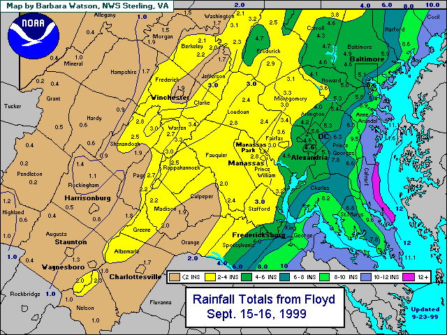
1999: Hurricane Floyd made landfall in North Carolina as a Category 2 hurricane on September 16.  Although gusty winds occurred in the DC Metro Area, Floyd’s primary legacy was significant flooding.  That’s because grounds were already saturated following several days of heavy, thunderstorm-related rainfall in late-August 1999, combined with the remnants of Hurricane Dennis earlier that September.  According to the National Weather Service, a total of 3.67” of rain occurred at National Airport on September 16 along with a peak wind gust of 55 mph.


Daily Rainfall Records (Source: National Weather Service)
September 17:

Washington, D.C. – Reagan National Airport (DCA): 3.26” (1876)
Dulles International Airport, (IAD), Sterling, Virginia: 1.71” (2004)
Baltimore, MD (BWI Marshall Airport): 3.94” (1876)


September 18:

DCA: 2.28” (2003)
IAD: 1.76” (2003)
BWI: 2.13” (2003)

Sunday, September 16, 2018

Weather Quiz


Hurricane Irene (Source: NOAA)
What was the last current or former hurricane to impact the DC Metro Area ?

A.  Floyd


B.  Irene

C.  Sandy

D.  Isabel

Thursday, September 13, 2018

Hurricane Florence will also Impact Inland Areas


NOAA rainfall forecast for Hurricane Florence
Hurricane Florence is about to make landfall in the Carolinas.  It will impact a large amount of land including areas far away from the coast.  The greatest risks inland will be torrential rainfall and flooding.  Check out an article I wrote for the WUSA9 website for more details.

Wednesday, September 12, 2018

Hurricane Florence and other Cape Verde Hurricanes


Florence becomes a Category 4 on September 10, 2018  (Source: NOAA)
Hurricane Florence is the first major Atlantic hurricane of 2018 and is poised to make landfall near the North and South Carolina border.  At peak intensity it was a Category 4 hurricane with sustained winds of 140 mph and a minimum central air pressure of 939 millibars – well below the standard sea level air pressure of 1013.25 millibars.  The National Hurricane Center expects Florence to weaken below Category 4 status before making landfall.

September is the busiest month of the Atlantic hurricane season because conditions are most favorable for tropical storm formation.  The longest-lasting hurricanes in the Atlantic are often “Cape Verde” hurricanes that develop in the eastern Atlantic Ocean near the Cape Verde Islands.  Florence is a “Cape-Verde” hurricane with a relatively long lifespan since it was first named a tropical storm on September 1. 

A “tropical storm” has sustained winds of 39-73 mph, while a “hurricane” has sustained winds of at least 74 mph.  According to NOAA, an average hurricane season in the Atlantic Ocean has a total of 12 tropical storms of which 6 becomes hurricanes, including 3 major hurricanes (Category 3 or higher with sustained winds of at least 111/+ mph).  That includes an average of up to 5 Cape Verde hurricanes in a given season. 

The track of Cape Verde hurricanes is largely dependent on a semi-permanent area of high pressure in the Atlantic Ocean known as the “Bermuda High.”  Air circulates in a clockwise direction around areas of high pressure in the Northern Hemisphere.  The Bermuda High is typically centered near the island of Bermuda, but its exact location often varies from one summer to the next. 

The Bermuda High has a large influence on where tropical storms and hurricanes track.  Cape Verde hurricanes can recurve northward over the open Atlantic and never threaten the East Coast of the United States, like Hurricane Erika (1997) and Hurricane Kate (2003) each did.  This tends to happen when the Bermuda High is situated farther east than normal.  There have been other seasons when the Bermuda High is centered farther west, and that guides Cape Verde hurricanes into the East Coast. 

There have been a significant number of destructive Cape Verde hurricanes that have made landfall along the East Coast, such as the 1933 “Chesapeake Bay” or “Chesapeake-Potomac” hurricane, Hurricane Gloria in 1985, Hurricane Hugo in 1989 and Hurricane Isabel in 2003.  Some people may also recall Hurricane Fran in 1996 and Floyd in 1999, which also fit this criteria.  Fran was the last Category 3 hurricane to make landfall in the Carolina’s, while Hugo was the last Category 4 hurricane to make landfall there.

Sometimes the Bermuda High doesn’t steer hurricanes northward until they’re much farther west.  For example, Hurricane Andrew in 1992, Hurricane Frances in 2004 and Hurricane Irma all made landfall in Florida and then had significant impacts along the U.S. Gulf Coast.  There have been other instances where Cape Verde hurricanes are kept south by the Bermuda High and impact Central America like Hurricane Dean in 2007.  Also, Hurricane Ike tracked over the island of Cuba and across the Gulf of Mexico before making landfall in Texas in 2008.

In conclusion, Hurricane Florence is the most recent in a long-line of Cape Verde hurricanes that is poised to become a destructive storm in the United States.

Sunday, September 9, 2018

Some of DC’s Most Destructive Hurricanes


Hurricane Floyd, September 1999 (Source: NOAA)

September is the most active month of the Atlantic hurricane season.  That’s especially so in 2018 when, after a quiet six-week period from mid-July to late August, multiple tropical systems are currently active in the Atlantic Ocean including Florence, Helene and Isaac.

Hurricane Florence is the one that residents along the East Coast should be watching most closely.  My colleagues and I on the WUSA9 Weather Team will be monitoring it carefully during the next few days.  

Longtime DC Area residents may recall some of the most significant tropical systems that have impacted the Mid-Atlantic Region in previous years.

2003:  Hurricane Isabel made landfall in North Carolina as a Category 2 hurricane on September 18.  Isabel tracked west of Washington, D.C. as it weakened and brought the DC Metro Area a significant amount of heavy rain and gusty winds.  Over one million power outages were observed around the Nation’s Capital, with significant coastal flooding in Old Town Alexandria in Virginia and in Annapolis, Maryland. 

The highest tide in Annapolis reached 7.58 feet above normal, breaking the 1933 hurricane record.  Flooding in Georgetown occurred with flood stage reaching 11.3 feet above normal and that also broke the 1933 hurricane surge record. 

1999: Floyd made landfall in North Carolina as a Category 2 hurricane on September 16.  It weakened as it tracked north to the DC Metro Area where it brought a prolific amount of rainfall.  National Airport got 3.67” of rain while Dulles Airport got 2.89”.  However, 4” to 7” rainfall totals were common in the DC Metro Area.  Washington, D.C. averages only 3.72” of rain during the entire month of September.

1972: Although Agnes was a minimal Category 1 hurricane at peak intensity, it was a tropical storm when it impacted the Mid-Atlantic Region.  After making landfall, Agnes quickly weakened and its remnants brought prolific amounts of rainfall and flooding to the Mid-Atlantic Region.  

In the DC Metro Region, Agnes brought a total of nearly 8.2” of rain to National Airport (with 6.11” falling on June 21) while Dulles Airport in nearby Sterling, Virginia, saw a storm total of 13.65” (including a daily record of 10.67” of rain on June 21).  This copious rainfall flooded an untold number roads and washed away some area bridges.  

The Potomac River at Little Falls crested more than 12 feet above flood stage, according to the U.S. Geological Survey.  As bad as the flooding was in the Nation’s Capital, it was even worse in Pennsylvania where it caused a dike to breach in Wilkes-Barre that almost destroyed the entire town.

1954: Hurricane Hazel made landfall in North Carolina on October 15 and traveled quickly northward.  It was a Category 4 hurricane upon landfall with sustained winds of 135 mph -- the only Cat 4 on the Saffir-Simpson Scale to make landfall in North Carolina.  Due to its relatively fast rate of speed northward, damaging winds occurred well inland.  

Washington, D.C. experienced its highest wind gust on record during Hazel of 98 mph at National Airport.  Significant storm surge occurred along the East Coast and in the Chesapeake Bay.

1933:  A hurricane known as the “Chesapeake Bay Hurricane” made landfall near Virginia Beach and traveled up the Chesapeake Bay and just west of Washington, D.C.  This caused very high storm surge on the west side of the Bay and in Washington, D.C. where the largest surge on record was observed (11 feet).  It also created the inlet at Ocean City, Maryland.  A total of 18 storm-related fatalities occurred, according to the National Weather Service.

Wednesday, September 5, 2018

Significant September Heat


Although DC’s average high/low temperatures both fall by 10° over the course of the month to 74°/57° on September 30, significant heat waves often occur in the Nation’s Capital.  A “heat wave” is defined as three or more consecutive days with high temperatures of at least 90°.  DC’s current heat wave began Monday, September 3 and will continue through tomorrow.  

A record-tying high temperature of 95° occurred yesterday in Washington, D.C.  That was the hottest temperature in the Nation’s Capital since July 16 (98°).  According to NOAA, today is DC’s eighth day in the 90s since August 27.  Making the current heat wave worse has been the very high relative humidity.  Humidity is “relative” to a given temperature since warmer air can hold more water vapor than cooler air.  That’s why higher relative humidity feels worse in the summer than it does in the winter.

Meteorologists look at the dewpoint temperature when calculating relative humidity.  The combination of air temperature and relative humidity produces the “heat index,” which is the feels-like temperature.  Some people consider the heat index to be summer’s equivalent to winter’s wind chill factor (i.e., the feels-like temperature in cold weather when you combine the temperature with the wind speed).  

The “dewpoint temperature” is the temperature at which 100% relative humidity or saturation occurs and dew forms.  If the dewpoint is below freezing, then frost develops.  Dewpoints in the 50s are comfortable, while dewpoints in the 70s are oppressive.  Dewpoint temperatures have been in the 70s for much of the last two weeks.  

The current heat wave is the most recent of memorable September heat waves that have occurred over the last decade in the Nation’s Capital.  Like this month, September 2008 got off to a hot start in Washington, D.C. with a four-day heat wave through September 5.  Also, September 2010 ranked among the ten warmest Septembers in Washington, D.C. and had two separate heat waves.  The longest occurred from September 22 – September 25, with September 24’s record high of 99°.  Washingtonians also experienced 90° on five of the first six days of September 2014.

Washingtonians also experienced two heat waves in September 2015, with the hottest temperature being 96° on September 3.  Finally, September 2016 tied with 1930 as DC’s third warmest September on record and had a total of seven 90° days.  Even rarer than a traditional heat wave in the Nation’s Capital is having three consecutive days of temperatures 95°/+.  That only occurred once in the last 30 years, from September 8 – 10, 2016.